Iowa Crop Progress and Condition Report
June 27 – July 3, 2022
DES MOINES, Iowa (July 5, 2022) — Iowa Secretary of Agriculture Mike Naig commented today on the Iowa Crop Progress and Condition Report released by the USDA National Agricultural Statistics Service. The report is released weekly April through November.
“Thunderstorms added to the fireworks over the extended 4th of July weekend with heavy rain falling across portions of the state,” said Secretary Naig. “Unfortunately, drought-stricken parts of northwestern Iowa missed out on higher totals. However, forecasts are pointing to moderate to heavy rain potential as we approach a critical time for corn and soybean development.”
The weekly report is also available on the USDA’s website at nass.usda.gov.
Crop Report
There was very little rain state-wide, resulting in 6.0 days suitable for fieldwork during the week ending July 3, 2022, according to the USDA National Agricultural Statistics Service. Fieldwork activities included completing the first cutting of hay, side dressing, and crop spraying.
Topsoil moisture conditions rated 7 percent very short, 27 percent short, 63 percent adequate and 3 percent surplus. Subsoil moisture conditions rated 7 percent very short, 25 percent short, 66 percent adequate and 2 percent surplus.
Corn began silking at 2 percent, 3 days behind last year and 4 days behind average. Corn condition rated 77 percent good to excellent. Thirteen percent of soybeans were blooming, 9 days behind last year and 4 days behind average. Iowa’s soybean condition rating was 77 percent good to excellent. Ninety-one percent of the oat crop was headed or beyond, 1 day behind last year. Twenty-three percent of oats were turning color, 6 days behind last year. Iowa’s oat condition was 79 percent good to excellent.
Ninety-five percent of the State’s first cutting of alfalfa hay has been completed and the second cutting was 23 percent complete. All Hay condition rated 69 percent good to excellent. Pasture condition rated 58 percent good to excellent. Livestock were showing some stress due to heat and humidity.
Weather Summary
Provided by Justin Glisan, Ph.D., State Climatologist, Iowa Department of Agriculture and Land Stewardship
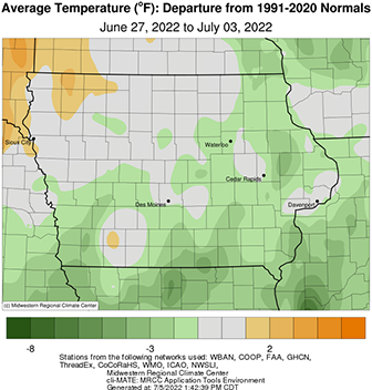
Unseasonably dry conditions exacerbated longer-term drought across northwestern Iowa as stations reported little to no rainfall over the previous week. Iowa’s southern one-third measured widespread rains but was still up to an inch below normal. Seasonal to slightly cooler temperatures were also observed with departures of up to three degrees in south-central Iowa; the statewide average temperature was 72.3 degrees, 0.70 degrees below normal.
Sunday (26th) afternoon conditions were pleasant across Iowa with gusty northwesterly winds, sunny skies and highs in the mid to upper 70s. Clear and chilly conditions persisted into Monday (27th) morning with mid-40s to mid-50s reported statewide; the state average low was 52 degrees, 10 degrees below normal. Winds were variable through the afternoon with a few passing cumulus clouds and hazy conditions in the southwest; daytime highs were near seasonal, generally in the upper 70s and low 80s. Morning lows reported near sunrise on Tuesday (28th) held in the low to mid 60s with a shifting southerly wind. Afternoon conditions were muggy with highs pushing into the mid to upper 80s ahead of a cold front dropping southeast into the Upper Midwest. A few isolated severe thunderstorms fired in advance of the boundary, producing heavy rain and a handful of half-dollar-sized hail near Kendallville (Winneshiek County). A narrow band of moderate rain also fell across Allamakee, Clayton and Dubuque counties. Skies cleared overnight with light winds, allowing pockets of fog to form in central to northeastern Iowa. High pressure took control of the region on Wednesday (29th) as sunshine and strong southerly winds drove afternoon temperatures into the upper 90s north to low 90s south.
Morning lows were unseasonably warm into Thursday (30th), ranging from the upper 60s south to mid 70s northwest. Spotty showers skirted the Iowa-Minnesota border through the late afternoon and evening hours as a weaker cold front moved through the state. Additional showers filled in over extreme southwest and south-central Iowa overnight into Friday (1st). Overall totals at 7:00 am were generally under the 0.20 inch measured at Lamoni Municipal Airport (Decatur County), though Chariton (Lucas County) picked up 0.58 inch. A few pop-up thunderstorms continued through southeastern Iowa as light rain moved over Iowa’s southern one-third into the afternoon, leaving behind minor totals; Columbus Junction recorded 0.60 inch from a heavier thundershower. Afternoon temperatures reached into the upper 70s and low 80s north, where the sun was shining, while cloud cover held temperatures to the low 70s south. Foggy conditions and poor air quality were reported over southern Iowa into Saturday (2nd), partially due to calm winds, high dewpoints and particulate from exploding fireworks. Daytime conditions were mostly sunny with light southerly winds and highs in the mid to upper 80s. Outflow from Minnesota thunderstorms fired an isolated cell in extreme northeast Iowa later in the afternoon, where a few stations observed rainfall. Mostly clear conditions continued into Sunday (3rd) morning with lows in the upper 50s and low 60s.
Weekly precipitation totals ranged from no accumulation at a majority of northwestern and east-central Iowa stations to 1.20 inches at a gauge near Cresco (Howard County). The statewide weekly average precipitation was 0.10 inch while the normal is 0.93 inch. Sioux City Airport (Woodbury County) reported the week’s high temperature of 100 degrees on the 29th, 16 degrees above normal. Battle Creek (Ida County) reported the week’s low temperature of 44 degrees on the 27th, 17 degrees below normal.

