Iowa Crop Progress and Condition Report
June 28 – July 4, 2021
DES MOINES, Iowa (July 6, 2021) — Iowa Secretary of Agriculture Mike Naig today commented on the Iowa Crop Progress and Condition report released by the USDA National Agricultural Statistics Service. The report is released weekly from April through November.
“Near-normal temperatures and generally dry conditions persisted across Iowa this past week with warmer daytime highs during the Fourth of July weekend,” said Secretary Naig. “As corn tassels in the coming weeks, forecasts show good chances of rainfall over much of the state, which would be beneficial for drought conditions and pollination.”
The weekly report is also available on the USDA’s website at nass.usda.gov.
Crop Report
Apart from Southeastern Iowa, little to no precipitation allowed farmers 5.7 days suitable for fieldwork during the week ending July 4, 2021, according to the USDA, National Agricultural Statistics Service. Field activities included spraying post emergence herbicides and harvesting hay.
Topsoil moisture levels rated 14% very short, 36% short, 48% adequate and 2% surplus. Subsoil moisture levels rated 18% very short, 45% short, 34% adequate and 3% surplus. Moisture levels vary widely as subsoil moisture levels in northwest Iowa rated 84% short to very short while levels in southeast Iowa rated 84% adequate to surplus.
Spotty rains benefitted crops but farmers reported more moisture is needed, especially in the northern two-thirds of the State. Across Iowa, there were scattered reports of corn silking. Iowa’s corn condition rated 62% good to excellent. Thirty-nine percent of soybeans were blooming, 6 days ahead of the five-year average. Five percent of soybeans are setting pods, 5 days ahead of normal. Soybean condition was rated 59% good to excellent. Oats headed or beyond reached 94% with 50% turning color, 4 days ahead of normal. There were scattered reports of oats for grain being harvested. Iowa’s oat condition rated 55% good to excellent.
The second cutting of alfalfa hay reached 30% complete, 1 day behind the 5-year average. Hay condition rated 54% good to excellent. Pasture condition was rated 39% good to excellent. Producers reported heat stressed livestock. Some producers had to start supplemental feeding.
Weather Summary
Provided by Justin Glisan, Ph.D., State Climatologist, Iowa Department of Agriculture and Land Stewardship
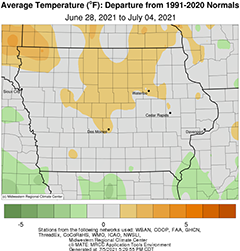
The end of June and first week of July brought more seasonal temperatures across much of Iowa with warmer conditions reported over the Fourth of July weekend; the statewide average temperature was 74.0 degrees, 0.9 degree above normal. While not as active as the previous reporting period, measurable rain fell at a majority of Iowa stations. Even with measurable rainfall, most of the state reported precipitation departures from 0.50 inch to over 1.00 inch at northern Iowa stations.
Spotty showers and storms popped up over northern Iowa through Sunday (27th) afternoon as a disturbance pushed into the region. Clouds and isolated dense fog were observed into Monday (28th) morning with temperatures ranging from the low 60s northwest to low 70s southeast. Additional showers and thunderstorms formed in northwestern and southern Iowa into the evening, producing locally heavy totals with slower cells in southern Iowa. Morning rainfall totals on Tuesday (29th) showed isolated amounts above an inch at multiple stations and general totals below 0.50 inch; a Community Collaborative Rain, Hail and Snow Network (CoCoRaHS) observer in Bloomfield (Davis County) emptied 1.75 inches. With clouds and rain persisting across southeastern Iowa, afternoon highs remained in the mid 70s while low 80s were reported farther north. Sluggish and very isolated thunderstorms popped from west-central Iowa into the northeast corner during the late afternoon and evening hours producing locally heavy downpours at a handful of stations; Perry (Dallas County) observed 1.78 inches while Monona (Allamakee County) reported 2.14 inches. Overnight temperatures into Wednesday (30th) remained warm under cloudy skies in southern Iowa, where readings stayed in the upper 60s and low 70s; northwestern Iowa experienced upper 50s under clear skies. Sunshine and afternoon highs in the low to mid 80s prevailed across Iowa’s northern three-quarters as a stationary front parked near the Iowa-Missouri border, producing clouds and moderate rain into the evening; the showers dissipated after the sunset.
Rainfall totals above an inch were observed at 7:00 am on Thursday (1st) in Clarke County and in Iowa’s southeastern corner; Morning Sun (Louisa County) measured 2.01 inches while two stations in Lee County reported 1.64 inches and 1.72 inches, respectively. Winds shifted to the northeast with partly cloudy conditions behind the front and afternoon temperatures in the low to mid 80s. Under the control of a high pressure system over the Midwest, mostly clear skies remained through the overnight hours into Friday (2nd) with morning lows dipping into the low to mid 60s. Daytime highs pushed into the upper 80s northwest to low 80s southeast. Clearing skies and calm winds allowed overnight temperatures to drop into the low 50s in northeastern Iowa. Winds shifted to a southerly direction through Saturday (3rd) as the high pressure center propagated east. With southerly flow and sunshine, afternoon conditions were warmer than average as temperatures climbed into the mid to upper 80s with several 90 degrees readings. Unseasonably warm temperatures persisted across northwestern Iowa into Sunday (4th) with positive departures of up to eight degrees above normal; Sioux Center (Sioux County) reported 70 degrees, 8.4 degrees above average.
Weekly precipitation totals ranged from no accumulation at multiple Iowa stations to 4.30 inches at a rain gauge near Harper’s Ferry (Allamakee County). The statewide weekly average precipitation was 0.39 inch while the normal is 0.98 inch. Several stations observed the week’s high temperature of 90 degrees on the 3rd, on average six degrees above normal. Elkader (Clayton County) reported the week’s low temperature of 52 degrees on the 3rd, eight degrees below normal.

