Iowa Crop Progress and Condition Report
July 26 – Aug. 1, 2021
DES MOINES, Iowa (Aug. 2, 2021) — Iowa Secretary of Agriculture Mike Naig commented today on the Iowa Crop Progress and Condition report released by the USDA National Agricultural Statistics Service. The report is released weekly from April through November.
“After a string of sweltering days, much-needed rainfall and cooler temperatures returned to Iowa over the weekend,” said Secretary Naig. “The weather outlooks for August show a higher likelihood of warmer temperatures, and we expect the smoke from the wildfires will continue over the next several days.”
The weekly report is also available on the USDA’s website at nass.usda.gov.
Crop Report
Most of the state received much needed rain Friday, July 30 and Saturday, July 31 which meant Iowa farmers had 5.9 days suitable for fieldwork during the week ending August 1, 2021, according to the USDA, National Agricultural Statistics Service. Field activities continue to include applying fungicides and insecticides and harvesting hay and oats.
Topsoil moisture levels rated 16% very short, 34% short, 49% adequate and 1% surplus. Subsoil moisture levels rated 20% very short, 41% short, 39% adequate and 0% surplus. Although moisture levels improved slightly in northwest Iowa, the shortage remains evident with topsoil rated 62% short to very short and subsoil rated 82% short to very short.
Corn silking or beyond reached 92%, one day ahead of the 5-year average. Corn in or beyond the dough stage reache 42%, four days ahead of average. Five percent of the corn crop has reached the dent stage. Iowa’s corn condition was rated 62% good to excellent. Ninety-three percent of soybeans were blooming, 9 days ahead of the 5-year average. Soybeans setting pods reached 73%, eight days ahead of normal. Soybean condition was rated 61% good to excellent. Oats coloring or beyond reached 97%. Seventy-two percent of oats for grain have been harvested, equal to the 5-year average.
The second cutting of alfalfa hay reached 92% complete. The third cutting was reported at 22% complete, 1 day ahead of the 5-year average. Hay condition rated 57% good to excellent. Pasture condition was rated 40% good to excellent. No livestock comments were received this week.
Weather Summary
Provided by Justin Glisan, Ph.D., State Climatologist, Iowa Department of Agriculture and Land Stewardship
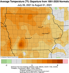
Beneficial rains fell across much of Iowa during the reporting period with above-average totals observed over portions of southern Iowa. Departures were observed in north-central Iowa on the order of up to an inch below normal. Along with an active storm track, sweltering conditions blanketed Iowa over several days with temperatures well into the 90s; the statewide average temperature was 76.0 degrees, 3.3 degrees above normal.
Mid to upper 80s were reported through Sunday (25th) afternoon along with sunny skies and variable winds. Overnight lows into Monday (26th) were in the 60s with scattered mid to upper 50s at some stations. Isolated showers also formed in north-central Iowa with light totals observed at a handful of stations; Webster City (Hamilton County) measured 0.07 inch. Winds shifted to a southerly direction with clear conditions through the day, allowing temperatures to rise back into the upper 80s. Dew point temperatures were also on the rise, signaling the stretch of hot and uncomfortable days to come. Morning temperatures reported on Tuesday (27th) at 7:00 am were warmest across northwest Iowa where low 70s were observed. Isolated thunderstorms popped up in extreme northeastern Iowa through the early afternoon hours leaving behind at least 1.00-inch totals across Allamakee and Winneshiek counties. An additional line of strong thunderstorms pushed over the Minnesota border and skirted the Iowa-Wisconsin border into the early hours on Wednesday (28th). One storm cell turned severe with a wind gust of 63 mph observed near Aurora (Buchanan County). Daytime conditions were very muggy with high relative humidity and temperatures in the low to mid 90s. The statewide average high was 92 degrees, eight degrees above normal. Another well-organized line of thunderstorms speeding south from Wisconsin pushed through the same parts of eastern Iowa. Six stations measured over two inches with a Community Collaborative Rain, Hail and Snow (CoCoRaHS) gauge in Camanche (Clinton County) measuring 2.89 inches. Rain amounts quickly tapered off to less than a few tenths of an inch farther west.
Scattered showers along a cold front remained over central and eastern Iowa through early Thursday (29th) with higher totals in the southeast corner from lingering storms. With winds shifting to a northerly direction behind the front, thick smoke from western and Canadian wildfires filtered into the state, leading to an Air Quality Alert on Friday (30th). Conditions through the day were muggy and hazy as upper-level smoke mixed down towards the surface. Temperatures ranged from the upper 70s southeast to mid 60s northwest, where clouds were increasing in advance of a large-scale weather disturbance. Moderate to heavy rain from widespread showers and thunderstorms was observed over Iowa’s southwest half. More than 50 stations measured an inch or more with pockets of above 2.50 inches in southwest and south-central Iowa; Oakland (Pottawattamie County) measured 2.55 inches while Knoxville (Marion County) reported 3.60 inches. Most stations across this southwest region observed at least 0.50 inch with the statewide average at 0.74 inch. Along with heavier rainfall, there were a few reports of damage from straight-line winds and golf ball-sized hail from isolated severe storms firing after midnight into Saturday (31st). As the system moved out of southern Iowa, skies cleared with near-seasonal daytime highs in the upper 70s and low 80s. Hazy skies persisted into Sunday (1st) with lows in the upper 50s and low 60s.
Weekly precipitation totals ranged from 0.01 inch at Sioux City Air National Guard Base (Woodbury County) to 3.76 inches in Knoxville. The statewide weekly average precipitation was 1.01 inches while the normal is 0.94 inch. Spencer Municipal Airport (Clay County) observed the week’s high temperature of 99 degrees on the 28th, 15 degrees above normal. Rockwell City (Calhoun County) reported the week’s low temperature of 52 degrees on the 1st, 11 degrees below normal.