Iowa Crop Progress and Condition Report
Sept. 6 – 12, 2021
DES MOINES, Iowa (Sept. 13, 2021) — Iowa Secretary of Agriculture Mike Naig commented today on the Iowa Crop Progress and Condition report released by the USDA National Agricultural Statistics Service. The report is released weekly from April through November.
“Unseasonably warm and dry conditions allowed farmers to ramp up fieldwork and some parts of the state may get an early start on harvest,” said Secretary Naig. “Outlooks continue to look favorable for harvest through the end of the month, and the fall season is shaping up to be warmer than average.”
The weekly report is also available on the USDA’s website at nass.usda.gov.
Crop Report
It was a very dry week across most of the state which allowed Iowa’s farmers 6.2 days suitable for fieldwork during the week ending September 12, 2021, according to the USDA, National Agricultural Statistics Service. Field activities included harvesting hay and corn silage. Some reports of old crop corn being moved to town prior to harvest were received.
Topsoil moisture levels rated 9% very short, 26% short, 63% adequate and 2% surplus. Subsoil moisture levels rated 14% very short, 37% short, 48% adequate and 1% surplus.
Crop maturity advanced across the State. Corn in or beyond the dent stage reached 87%, three days ahead of the 5-year average. Almost one-third of the corn crop has reached maturity, two days ahead of normal. Iowa’s corn condition rated 59% good to excellent. There were scattered reports of corn for grain being harvested. Soybeans coloring or beyond reached 67%, three days ahead of the 5-year average. Soybeans dropping leaves reached 30%, also three days ahead of normal. Soybean condition was rated 62% good to excellent. There were also a few isolated reports of soybeans being harvested during the week.
The third cutting of alfalfa hay reached 92% complete, two days ahead of the 5-year average. In some areas of the State farmers were starting on the fourth cutting of hay. Pasture condition was rated 35% good to excellent. In general, livestock has done well in spite of the heat. There were reports of low water levels in creeks and ponds for livestock use.
Weather Summary
Provided by Justin Glisan, Ph.D., State Climatologist, Iowa Department of Agriculture and Land Stewardship
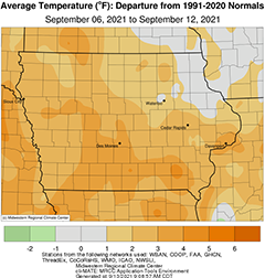
After a stretch of wetter than normal weeks, unseasonably dry conditions returned to Iowa over the reporting period; only a handful of stations observed measurable rainfall, though these totals were well below normal. Generally warmer temperatures were also felt across much of the state with positive departures over three degrees observed across southern Iowa. The statewide average temperature was 68.5 degrees, 1.2 degrees above normal.
Winds switched to a westerly direction through the afternoon on Sunday (5th) as highs remained comfortably in the low 80s statewide. Very spotty showers popped up over northwestern Iowa but dissipated by the evening hours; several stations reported very light rainfall with a trace observed near Eagle Grove (Wright County) to 0.22 inch at two gauges in Lyon County. Overnight lows into Monday (6th) ranged from isolated upper 40s northwest to upper 50s southeast with spotty dense fog observed at multiple stations. Southerly winds and sunny skies throughout the day pushed temperatures into the mid to upper 80s. Conditions remained clear and unseasonably warm through early morning with lows in the upper 60s; Guthrie Center (Guthrie County) reported a low of 71 degrees, 17 degrees above average. Upper-level wild fire smoke led to hazy conditions after sunrise on Tuesday (7th) as a cold front approached Iowa’s northwest corner. The front moved through central Iowa by noon, shifting winds to a northerly direction and clearing the sky of lingering smoke. As the front moved out of southeastern Iowa, isolated thundershowers formed along the Iowa-Illinois border but did not produce measurable rainfall. Behind the cold front temperatures dropped into the low to mid 50s under starry skies. Gusty northwesterly winds built in on Wednesday (8th) under brilliant sunny skies as very pleasant conditions and high pressure dominated the Upper Midwest. Daytime highs reached into the 70s with cirrocumulus clouds pushing though eastern Iowa.
Overnight lows into Thursday (9th) were chilly in northwestern Iowa, where low 40s were reported. The rest of Iowa experienced clear skies and lows in the upper 40s to low 50s southeast; the statewide average low was 49 degrees, five degrees below normal. Another comfortable day was in store for Iowa as afternoon highs remained in the mid to upper 70s with light, variable winds and generally clear skies; partly sunny skies were observed in eastern Iowa as a large low pressure center north of the Great Lakes spun cumulus clouds into the region. Under light southeasterly winds, overnight lows into Friday (10th) stayed warmer than the previous morning, spanning the mid 50s east to low 60s southwest. An end-of-week heat-up began during the afternoon as southerly winds and sunshine boosted highs into the mid to upper 80s. Saturday (11th) morning temperatures stayed in the upper 50s and low 60s with patchy fog at some stations. A weaker low pressure system began transiting the state though the afternoon hours as temperatures rose into upper 80s and low 90s; the statewide average high was 88 degrees, 11 degrees above normal. Light showers formed along the low’s attendant cold front with totals reported at 7:00 am on Sunday (12th) ranging from 0.01 inch at multiple northwestern Iowa stations to 0.05 inch at Rock Rapids (Lyon County).
Weekly precipitation totals ranged from no accumulation at a majority of stations to 0.22 inch near Lester and Rock Rapids (Lyon County). The statewide weekly average precipitation was 0.01 inch while the normal is 0.83 inch. Perry (Dallas County) observed the week’s high temperature of 93 degrees on the 11th, 15 degrees above normal. Battle Creek (Ida County) and Spencer Municipal Airport (Clay County) reported the week’s low temperature of 44 degrees on the 9th, on average eight degrees below normal.

