Iowa Crop Progress and Condition Report
September 12 – 18, 2022
DES MOINES, Iowa (Sept. 19, 2022) — Iowa Secretary of Agriculture Mike Naig commented today on the Iowa Crop Progress and Condition Report released by the USDA National Agricultural Statistics Service. The report is released weekly April through November.
“Despite widespread rainfall over the weekend, we anticipate unseasonably warm and dry weather will continue through the end of September, setting up ideal conditions as harvest activities ramp up,” said Iowa Secretary of Agriculture Mike Naig. “As we recognize National Farm Safety and Health Week this week, I want to encourage Iowans to keep safety on the roads and in the fields top of mind this harvest season.”
The weekly report is also available on the USDA’s website at nass.usda.gov.
Crop Report
Widespread rainfall across the State resulted in 5.8 days suitable for fieldwork during the week ending September 18, 2022, according to the USDA, National Agricultural Statistics Service. Row crop harvest has begun, and other fieldwork included chopping silage, cutting hay, and seeding cover crops. Producers were also preparing equipment and bins for harvest.
Topsoil moisture condition rated 14 percent very short, 28 percent short, 57 percent adequate and 1 percent surplus. Subsoil moisture condition rated 19 percent very short, 31 percent short, 49 percent adequate and 1 percent surplus.
Corn in the dent stage or beyond was 93 percent, 5 days ahead of the 5-year average. Forty-two percent of Iowa’s corn crop was mature, 2 days behind last year but equal to the average. Harvest of the State’s corn crop began with 2 percent complete. Corn condition was 64 percent good to excellent. Seventy-five percent of soybeans were coloring or beyond, 3 days behind last year. Soybeans dropping leaves were at 30 percent, almost 1 week behind last year and 3 days behind the 5-year average. Soybean condition remained 63 percent good to excellent.
Ninety-four percent of the State’s third cutting of alfalfa hay was complete. Pasture condition rose slightly to 34 percent good to excellent. Some producers have livestock on dry lots due to lack of water in pastures.
Weather Summary
Provided by Justin Glisan, Ph.D., State Climatologist, Iowa Department of Agriculture and Land Stewardship
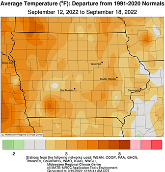
Unseasonably warm temperatures held on through the last full week of summer with positive departures approaching six degrees in northwestern Iowa; the statewide average temperature was 67.6 degrees, 4.2 degrees above normal. Widespread and beneficial rains fell over southern Iowa with some severe thunderstorms producing pockets of large hail and high winds.
Northerly winds gradually weakened into Sunday (11th) evening with daytime temperatures holding in the low to mid 70s as puffy, fair-weather cumulus dotted the sky. Overnight lows were chilly across northwestern Iowa where the upper 30s were reported before the sun rose on Monday (12th) morning; low 50s were recorded in eastern Iowa where cloud cover remained. Sunny conditions persisted across Iowa’s western three-quarters as afternoon temperatures pushed into the mid to upper 70s. Light showers spun into eastern Iowa on the backside of a low pressure system leaving behind meager totals. Variable winds developed after midnight as temperatures ranged from the low 40s northwest to low 50s southeast through the morning hours. Skies remained generally cloudless on Tuesday (13th) with temperatures reaching into the mid-80s west to mid-70s east. Patchy fog formed in the early hours of Wednesday (14th) in eastern Iowa where windless conditions were found. Morning conditions were mostly clear with temperatures in the 50s. Stronger southerly winds helped boost daytime highs into the upper 80s and low 90s over western and southern Iowa; the statewide average high was 85 degrees, eight degrees above normal.
Temperatures on Thursday (15th) were cooler than the previous day, hovering in the upper 70s and low 80s, as southerly winds became gusty. Clouds pushed into western Iowa late in the evening and through much of Friday (16th) as a low pressure center approached the state. Showers and thunderstorms formed ahead of a cold front, leaving measurable rain totals across the western half of Iowa; amounts were generally under 0.20 inch, though Rock Rapids (Lyon County) measured 0.60 inch while Little Sioux (Harrison County) reported 0.83 inch. Thunderstorms formed overnight in western Iowa and pushed through southern Iowa for most of Saturday (17th). Afternoon temperatures stayed in the upper 60 and low 70s in southern Iowa where clouds and rain were present. Severe storms refired later in the evening, producing several reports of straight-line winds and large hail; a 3.5-inch diameter hailstone was observed in Carson (Pottawattamie County), producing structural damage. Heavy downpours were observed in stronger storms as almost 30 stations measured at least an inch of rain with 10 stations reporting more than two inches; a rain gauge in Chariton (Lucas County) dumped out 4.00 inches. Most of southern Iowa received at least 0.50 inch. Thunderstorms dissipated by 7:00 am on Sunday (18th) as dense fog formed with morning lows generally in the low 60s.
Weekly precipitation totals ranged from no accumulation at several northeastern stations to 4.20 inches at Pella (Marion County). The statewide weekly average rainfall was 0.63 inch while the normal is 0.77 inch. Little Sioux (Harrison County) reported the week’s high temperature of 92 degrees on the 14th, 15 degrees above normal. Several northwestern stations reported the week’s low temperature of 39 degrees on the 12th, on average 13 degrees below normal.

