Iowa Weekly Weather Summary
Oct. 20-26, 2025
DES MOINES, Iowa (Oct. 27, 2025) – Iowa Secretary of Agriculture Mike Naig commented on the Iowa Department of Agriculture and Land Stewardship’s weekly weather summary released today. Information from the Iowa Crop Progress and Condition Report, which is released weekly by the United States Department of Agriculture National Agricultural Statistics Service from April through November, was not available due to the federal government shutdown.
“Looking at the five-year average, Iowa typically has more than 90 percent of soybeans and three-quarters of corn harvested by the last week in October. The dry conditions have allowed farmers to push that pace, with farmers in some parts of the state wrapping up harvest and transitioning to other field work,” said Secretary Naig. “Much of Iowa also experienced the first hard freeze of the season as overnight temperatures dropped. Though scattered rain is possible in parts of the state this week, any pause in field work is likely to be short-lived. Outlooks indicate warmer and drier conditions returning as we head into November.”
Weather Summary
Provided by Justin Glisan, Ph.D., State Climatologist, Iowa Department of Agriculture and Land Stewardship
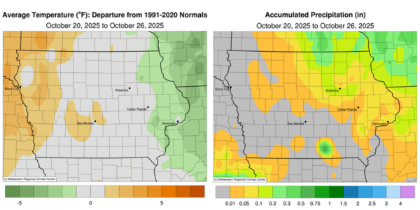
After a six-week stretch of unseasonably warm temperatures, conditions moderated to near normal across much of Iowa during the reporting period. The first widespread frost and freeze event also occurred, with numerous stations reporting the end of the growing season. The statewide average temperature was 50.0 degrees Fahrenheit, which matches the 30-year climatological mean. Most of the state also experienced unseasonably dry conditions, with departures of more than 0.50 inch at many stations.
Gusty westerly winds subsided through Sunday (19ᵗʰ) afternoon under sunny skies, with daytime highs in the upper 50s and low 60s. Starry skies were visible into early Monday (20ᵗʰ) morning as winds shifted to a southerly direction and temperatures remained in the 40s statewide. A cold front associated with a low-pressure center moving across northern Minnesota gradually crossed the state, producing light showers. Afternoon temperatures reached the upper 50s behind the front, while cloud cover in eastern Iowa held readings in the upper 60s and low 70s. Skies cleared by midnight as winds returned to a westerly direction, though clouds redeveloped by sunrise on Tuesday (21ˢᵗ). Rain totals from the system were generally light, with the highest amounts in northeastern Iowa; Lansing (Allamakee County) recorded 0.10 inch, while Waterloo (Black Hawk County) observed 0.16 inch. Many stations farther south and west reported less than 0.10 inch. Strong northwesterly winds developed through the day as low stratus clouds blanketed the state, producing chilly temperatures ranging from the upper 40s in the north to the mid 50s in the south. Mason City Municipal Airport (Cerro Gordo County) registered a 53-mph gust, with sustained winds in the 20- to 30-mph range statewide. A few light showers wrapped in behind the low-pressure system, bringing additional totals under 0.10 inch to northeastern stations. Clouds lingered over eastern Iowa into Wednesday (22ⁿᵈ), with the rest of the state under clear skies. Morning lows dropped below freezing on a widespread basis for the first time this season; stations in western and northern Iowa reported temperatures in the mid 20s, with Spencer Municipal Airport (Clay County) recording 25 degrees — ten degrees below normal. Afternoon conditions were calm as high pressure dominated the Upper Midwest, with highs in the low 50s across northern Iowa and up to ten degrees warmer in the south.
Thursday (23ʳᵈ) began chilly, as 35 stations recorded temperatures at or below 28 degrees — the threshold for a killing freeze. The statewide average low was 30 degrees, seven degrees below normal under mostly clear skies. Daytime highs rose into the upper 50s and low 60s as northwesterly winds lightened and ample sunshine prevailed. Easterly winds developed on Friday (24ᵗʰ) morning, accompanied by pockets of frozen fog in northeastern Iowa. Temperatures held in the upper 20s across northern stations and the upper 30s farther south; stations in extreme southwest Iowa reported upper 40s under cloudy skies. Daytime conditions were near seasonal, with increasing cloud cover across western Iowa and southeasterly winds. Overcast conditions persisted into Saturday (25ᵗʰ), with overnight lows in the upper 40s and low 50s—much warmer than during previous mornings. Scattered showers developed across a north-central corridor of Iowa later in the evening and continued overnight, yielding 0.10 inch in Mason City and 0.35 inch in Osage (Mitchell County). Cloudiness continued into Sunday (26ᵗʰ), with lows ranging from the mid- to upper 40s statewide.
Weekly precipitation totals ranged from no measurable accumulation in western and southern Iowa to 0.44 inch in Osage. The statewide weekly average precipitation was 0.01 inch, compared with a normal of 0.63 inch. Clarinda (Page County) reported the week’s highest temperature of 74 degrees on the 19ᵗʰ, ten degrees above normal. Vinton (Benton County) recorded the week’s lowest temperature of 21 degrees on the 24ᵗʰ, thirteen degrees below normal.