Weekly Weather Summary
Nov. 3 – 9, 2025
DES MOINES, Iowa (Nov. 10, 2025) – Iowa Secretary of Agriculture Mike Naig commented on the Iowa Department of Agriculture and Land Stewardship’s weekly weather summary released today. Information from the Iowa Crop Progress and Condition Report, which is released weekly by the United States Department of Agriculture National Agricultural Statistics Service from April through November, was not available due to the federal government shutdown.
“Based on my observations while traveling around the state and the conversations I’m having with farmers, harvest appears to be nearly complete. That’s in line with the five-year average, which shows Iowa typically has about 98% of soybeans and 91% of corn harvested by mid-November,” said Secretary Naig. “There was a notable weather shift over the weekend as many parts of the state received the first snowfall of the season and snow blanketed much of northwest Iowa. Temperatures fell into the teens and low 20s across much of the state, marking the official end of the growing season. Looking ahead, forecasts call for warmer conditions and an increased chance of rainfall during the second half of the month.”
Weather Summary
Provided by Justin Glisan, Ph.D., State Climatologist, Iowa Department of Agriculture and Land Stewardship
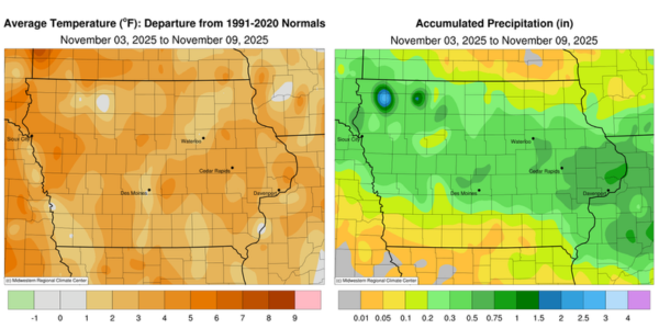
The first snowfall of the season was reported across portions of Iowa late in the reporting period along with a nose-dive in temperatures. Much of the state observed rainfall as well, with above-normal moisture in northwest and eastern Iowa. Weekly conditions were still above normal with the statewide average temperature at 47.2 degrees, 3.4 degrees above normal.
Dry conditions prevailed from Sunday (2nd) afternoon through Thursday (6th) with daytime temperatures in the mid 50s to low 60s over the span of days. Cloud cover increased over northern Iowa through Friday (7th) as a low pressure system approached the state from the Dakotas. Rain showers pushed into western Iowa on Saturday (8th) morning with snow showers developing over northwestern Iowa. Rain and snow continued across much of the state through the afternoon and evening hours with snow accumulating over northwestern Iowa. Strong northwesterly winds built in as the system exited Iowa into Sunday (9th) morning as temperatures plummeted into the teens and low 20s at most stations. More than 50 stations observed the first measurable snow of the season with totals ranging from 0.1 inch in Mason City (Cerro Gordo County) to 5.1 inches in Pocahontas (Pocahontas County). Rainfall totals were more widespread with general totals in the 0.25-0.50 inch range; stations in eastern Iowa recorded higher amounts with 0.96 inch in Long Grove (Scott County).
Weekly precipitation totals ranged from 0.02 inch at Lamoni Municipal Airport (Decatur County) to 1.03 inches in Long Grove. The statewide weekly average precipitation was 0.28 inch, while the normal is 0.52 inch. Donnellson (Lee County) reported the week’s high temperature of 72 degrees on the 4ᵗʰ, 17 degrees above normal. Emmetsburg (Palo Alto County) and Sibley (Osceola County) recorded the week’s low temperature of 13 degrees on the 9th, on average 14 degrees below normal.