Iowa Weekly Weather Summary
Oct. 6 – Oct. 12, 2025
DES MOINES, Iowa (Oct. 13, 2025) — Iowa Secretary of Agriculture Mike Naig commented on the Iowa Department of Agriculture and Land Stewardship’s weekly weather summary released today. Information from the Iowa Crop Progress and Condition Report, which is released weekly by the United States Department of Agriculture National Agricultural Statistics Service from April through November, was not available due to the federal government shutdown.
“Based on the crop progress reports published over the past five years, Iowa farmers typically have about two-thirds of the soybeans and one-third of the corn harvested statewide by mid-October. As I’ve visited with farmers, driven through rural parts of the state, and spent several days in the field on our family farm in northwest Iowa, it seems that harvest is about where we’d expect this time of year,” said Secretary Naig. “Looking ahead, rain chances remain in the forecast through the end of the month. Farmers will continue to push forward with harvest, cover crop seeding and other field work as the weather allows.”
Weather Summary
Provided by Justin Glisan, Ph.D., State Climatologist, Iowa Department of Agriculture and Land Stewardship
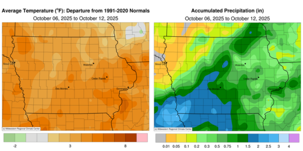
While not as warm as the previous week, temperatures across Iowa remained four to six degrees above normal, with a statewide average temperature of 61.4 degrees, 5.3 degrees above the 30-year climatological mean. Widespread rainfall also returned to the state, with southwestern stations observing positive departures ranging from 1.00 to 2.00 inches, while northwestern stations experienced the driest conditions.
A cold front swept across Iowa on Sunday (5ᵗʰ) afternoon, bringing measurable rainfall to many reporting stations statewide. A southwest-to-northeast swath of stations recorded the highest amounts, with more than 50 stations observing 1.00 inch or greater. Several stations in southwestern and central Iowa observed totals exceeding 2.00 inches; Boone (Boone County) registered 2.02 inches, while Red Oak (Montgomery County) reported 2.50 inches. Totals northwest and southeast of the swath ranged from 0.25 to 0.50 inch, with a statewide average of 0.41 inch. Overcast conditions persisted into Monday (6ᵗʰ) as rain showers continued over the southeastern half of the state. Morning temperatures varied from the mid 40s in the northwest, where skies were clear, to the low 60s in the southeast, ahead of the cold front. Light to moderate rain persisted into the evening hours, with southern and eastern stations recording additional totals from 0.25 to 0.75 inch; Davenport (Scott County) received 1.00 inch, and Pacific Junction (Mills County) recorded 1.54 inches. Skies cleared across most of Iowa by Tuesday (7ᵗʰ), with temperatures in the mid-30s across northwestern stations and up to 20 degrees warmer in southeastern Iowa, where cloud cover remained. High pressure dominated the Upper Midwest as winds shifted to a northerly direction throughout the daylight hours, under sunny skies and with highs in the mid to upper 60s.
Wednesday (8ᵗʰ) began with chilly temperatures across northern Iowa, with readings in the mid to upper 30s at numerous stations. Winds became variable by afternoon, and daytime temperatures rose into the upper 60s and low 70s. Cloud cover increased over western Iowa on Thursday (9ᵗʰ) as another weak cold front approached the state. Afternoon temperatures reached the 70s, and southerly winds became gusty into the evening hours. Scattered showers and isolated thunderstorms developed over central Iowa, expanding northeast and southwest along the advancing front. The convective complex moved southeast and exited the state by sunrise on Friday (10ᵗʰ). Rainfall totals were widespread across southeastern Iowa, with the highest amounts recorded in south-central areas; Lamoni (Decatur County) observed 0.55 inch, Osceola (Clarke County) reported 0.80 inch and Allerton (Wayne County) received 1.22 inches. Skies cleared behind the front, accompanied by brisk northwesterly winds and afternoon temperatures in the 70s. Overnight lows fell into the 40s statewide as light easterly winds developed. Saturday (11ᵗʰ) was a pleasant, sunny day with blustery southeasterly winds, low humidity and temperatures ranging from the upper 60s north to the mid 70s south. Partly cloudy conditions developed on Sunday (12ᵗʰ) as winds strengthened ahead of an approaching system over western Iowa. Morning lows ranged from the low 50s in the southeast to the low 60s in the northwest.
Weekly precipitation totals ranged from no accumulation at multiple northwest stations to 3.00 inches in Red Oak and Shenandoah (Page County). The statewide weekly average precipitation was 0.63 inch, slightly below the normal of 0.65 inch. Several stations reported the week’s high temperature of 88 degrees on the 5th, on average 21 degrees above normal. Sioux Center (Sioux County) recorded the week’s low temperature of 31 degrees on the 7ᵗʰ, 12 degrees below normal.