About
Project name: Price Creek
Watershed size: 18,838 acres
Year began: 2007
Year Complete: Ongoing
SWCD Contact: Iowa Purpose: Improve water quality
Partners
Soil and Water Conservation District(s): Iowa, Benton
Other partners: Iowa Department of Agriculture and Land Stewardship, Iowa Department of Natural Resources, Environmental Protection Agency, Natural Resources Conservation Service
Description
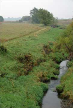
Narrow ridges and steep slopes along Price Creek set the natural landscape up for heavy erosion and sediment loads into the creek if conservation measures aren’t taken.
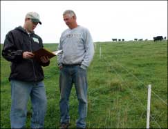
Through the Price Creek Watershed Project, practices that fit the land are being adopted by local landowners. One landowner who has steep land adjoining the creek has fenced cattle away from the creek, and is using offstream watering facilities with water pumped via pipeline to the center of his pastures. Fencing that separates rotational pastures in a prescribed grazing system is done in a manner to give cattle access to water from all the pastures. Rotational grazing encourages faster regrowth of forages, and protects steep hills from erosion.
Through the Iowa and Benton County Soil and Water Conservation Districts, the Iowa Department of Agriculture and Land Stewardship (IDALS) Division of Soil Conservation has offered technical assistance and $5600 in cost-share funds for conservation improvements. Other partners, including the Iowa Department of Natural Resources, have contributed $205,000.
According to IDALS Project Coordinator James Martin, the project is targeting the most critically eroding areas and seeking to keep livestock out of 50 percent of the Price Creek corridor, as well as reduce nutrient loading and bacteria levels from livestock and human waste.
Protecting stream banks in critical areas is part of the overall plan, along with terraces and water and sediment control basins to slow erosion from croplands.