Iowa Weekly Growing Season Report
Preliminary weather summary for the week July 20-26, 2026
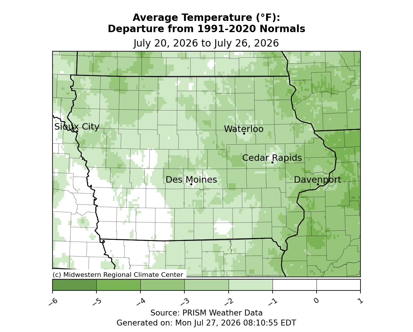
An active start to the week brought severe thunderstorms from central to eastern Iowa. The remainder of the reporting period was much less active with rainfall reported on a few days. Temperatures swung to below normal for much of the state with departure of up to three degrees below average; the statewide average temperature was 72.2 degrees, 1.3 degrees below normal.
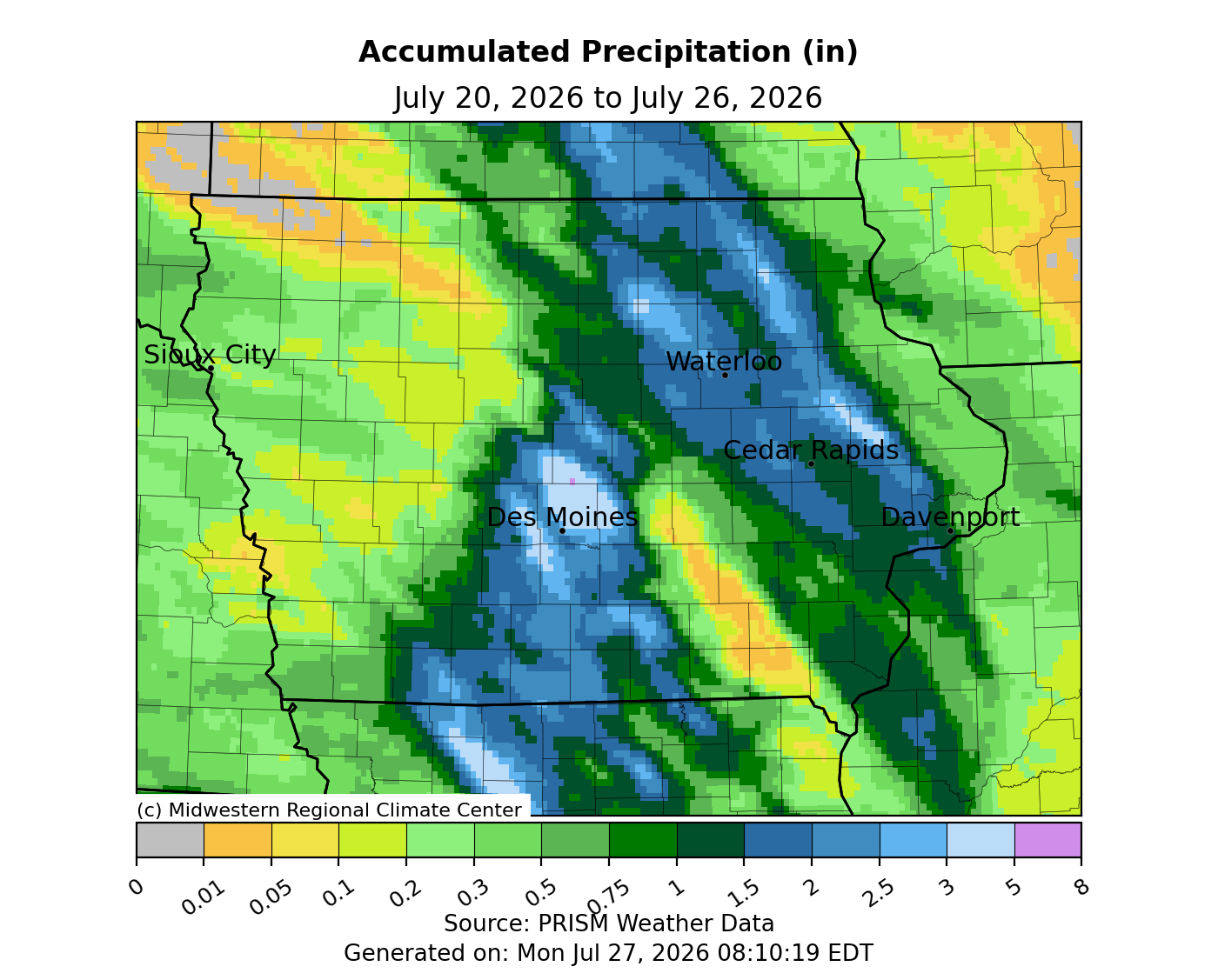
Dense smoke from Ontario wildfires mixed down to the surface across eastern Iowa into Sunday (19th) afternoon, creating air quality issues. Highs were also seasonal under the smoke with mid to upper 80s in western Iowa. A southerly shifting wind overnight into Monday (20th) helped jack up air and dewpoint temperatures. A line of strong thunderstorms pushing across southeastern Minnesota dove into northwest Iowa by sunrise and continued through eastern Iowa through early afternoon. The line produced strong wind gusts, with a 70 mph reading in Lafayette (Linn County) along with torrential downpours that led to flash flooding across Muscatine and Scott counties. Two supercells rapidly formed over north-central Iowa a few hours later ahead of a strong cold front moving south into the state. Ahead of the front, ample instability was present along with temperatures in the low to mid 90s and dew points in the upper 70s. The supercells merged as they travelled southeast, intensifying as the line expanded over central Iowa. The complex split with the eastern branch moving over the same path as the morning mesoscale convective complex. The supercells moving down the I-35 corridor produced hail in the 2.00-3.00-inch diameter range along with two reports of tornadoes in Hamilton County, south of Webster City and near Kamrar. Wind gusts between 40-60 mph were also widespread as the line sped towards the Iowa-Missouri border. A weaker line of thunderstorms expanded west off the existing line into the southwest corner. The cold front exited the state just after daybreak with wind shifting to the north under clear skies and temperatures from 60s north to low 70s south. Rain totals were highest across central to south-central Iowa and in a separate swath in the northeast. More than half of Iowa’s reporting stations collected at least 1.00 inch with nearly 75 at 2.00 inches or above. Two stations in Ames (Story County) registered 3.93 to 3.95 inches while two stations in Ankeny (Polk County) observed 3.91 to 4.40 inches; while much of northwest Iowa remained dry, the overall statewide average was 1.14 inches.
Tuesday (21st) was a pleasant day with reduced humidity, mostly sunny skies and temperatures in the upper 70s. Overnight lows into Wednesday (22nd) ranged from the mid 50s north to low 60s south with light northerly winds. Daytime highs were unseasonably cool, holding in the low 70s statewide under somewhat cloudy skies. Thursday (23rd) started chilly with morning lows well below normal; the statewide average low was 55 degrees, eight degrees cooler than normal. Temperatures warmed into the mid to upper 70s while cloud cover and light southerly winds persisted. Showers formed later in the evening over northwest Iowa and expanded farther south and east into early Friday (24th) morning. Rain tapered off into the early afternoon hours, though overcast skies remained with temperatures holding in the 70s. Foggy conditions developed into Saturday (25th) morning with unseasonably warm morning temperatures in the upper 60s to low 70s. Clear skies and southerly winds over western Iowa helped push temperatures into the low 90s while patchy clouds held temperatures in the 80s across the state. Iowans woke up to very muggy conditions on Sunday (26th) with air and dew point temperatures in the 70s.
Weekly precipitation totals ranged from no measurable amounts at few of Iowa’s stations to 5.84 inches in Dallas Center (Dallas County). The statewide weekly average precipitation was 0.99 inch; the normal is 0.89 inch. Multiple stations reported the week’s high temperature of 101 degrees on the 20th, on average 15 degrees above normal. Spencer Municipal Airport (Clay County) reported the week’s low temperature of 45 degrees on the 23rd, 18 degrees below normal.